

 Using electronic tags, scientists have been able to track the migration of the sooty shearwater from its breeding grounds in the southern hemisphere to its wintering grounds in the North Pacific. Twice a year the shearwaters travel a figure-eight pattern around the Pacific to take advantage of the summer season in each hemisphere. This loop is the longest known travelling distance for any bird species. Each bird completed it in about 200 days.
The flights of sooty shearwaters documented in this new study represent the longest animal migration routes ever recorded using electronic tracking technology: around 65,000 kilometers (39,000 miles). Taking advantage of prevailing winds along different parts of the migration route, the birds trace giant figure eights over the Pacific Basin.Not all birds travel the entire circumference of the Pacific. Electronic tracking has shown that most go to a single feeding area for the northern summer and then return straight to New Zealand for their breeding season. Put together, the tagged birds covered most of the Pacific. This map from the BBC displays the routes.
"The only other bird species known that could rival the migrations of the sooty shearwater would be the arctic tern, which breeds in the Arctic and migrates to Antarctica. But we don't know if they do that in a single season, because nobody's ever tracked them," said Scott Shaffer, a research biologist at the University of California, Santa Cruz, and first author of a paper describing the new findings, published in next week's online early edition of Proceedings of the National Academy of Sciences (PNAS).
Shaffer worked with an international team of scientists from UCSC and other institutions in the United States, New Zealand, and France. The researchers found that the migratory cycle of sooty shearwaters encompasses the entire Pacific Basin, focusing on the richest feeding grounds in both hemispheres--from Antarctic waters in the south during the breeding season to bountiful coastal currents off California, Alaska, and Japan in the north. These small seabirds cross the equator twice a year in pursuit of an endless summer in which their feeding areas are always at or near the period of peak productivity....
Diving patterns recorded by the tags indicate the birds stop little if at all to feed as they pass through the equatorial regions on their journey between the Southern and Northern Hemispheres.
"When they cross the equator, they're traveling fast and not stopping much to feed. They feed near Antarctica during the austral summer, then zip north to feed in one of three areas of the North Pacific, taking advantage of high productivity throughout the year," Shaffer said.
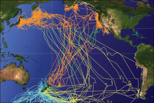 Blue lines represent breeding season movement, yellow lines show northward migration, and orange lines cover the wintering areas and southbound routes. The map is based on tags recovered from 19 shearwaters in New Zealand after their journey was complete.

